Wadi Bani Awf Off-Road: Oman's Most Spectacular Mountain Drive
Is Wadi Bani Awf suitable for a standard hire 4WD?
Yes, with an experienced driver. The route requires low-range 4WD, high clearance, and careful navigation. Allow a full day and carry extra water and fuel.
Oman’s Most Challenging and Most Rewarding Mountain Drive
There are paved roads that offer spectacular scenery. There are graded tracks that provide access to remote places. And then there is Wadi Bani Awf — a route of a different category entirely, one that requires genuine 4WD capability, careful judgement, and a day that begins early. The reward for that commitment is a journey through one of the most extraordinary mountain landscapes in Arabia, through a canyon system that has no real parallel anywhere in the region, and along a road that connects the coast to the interior in a way that makes both destinations feel new.
The route runs from the Al Batinah coastal plain through the heart of the Al Hajar mountains to the village of Bilad Sayt — arguably the most dramatically situated village in Oman — and out through the high plateau toward Rustaq. Or it can be driven in reverse. Either direction reveals different aspects of the same extraordinary terrain, and experienced off-road drivers have their preferences.
Understanding the Route
The Overall Corridor
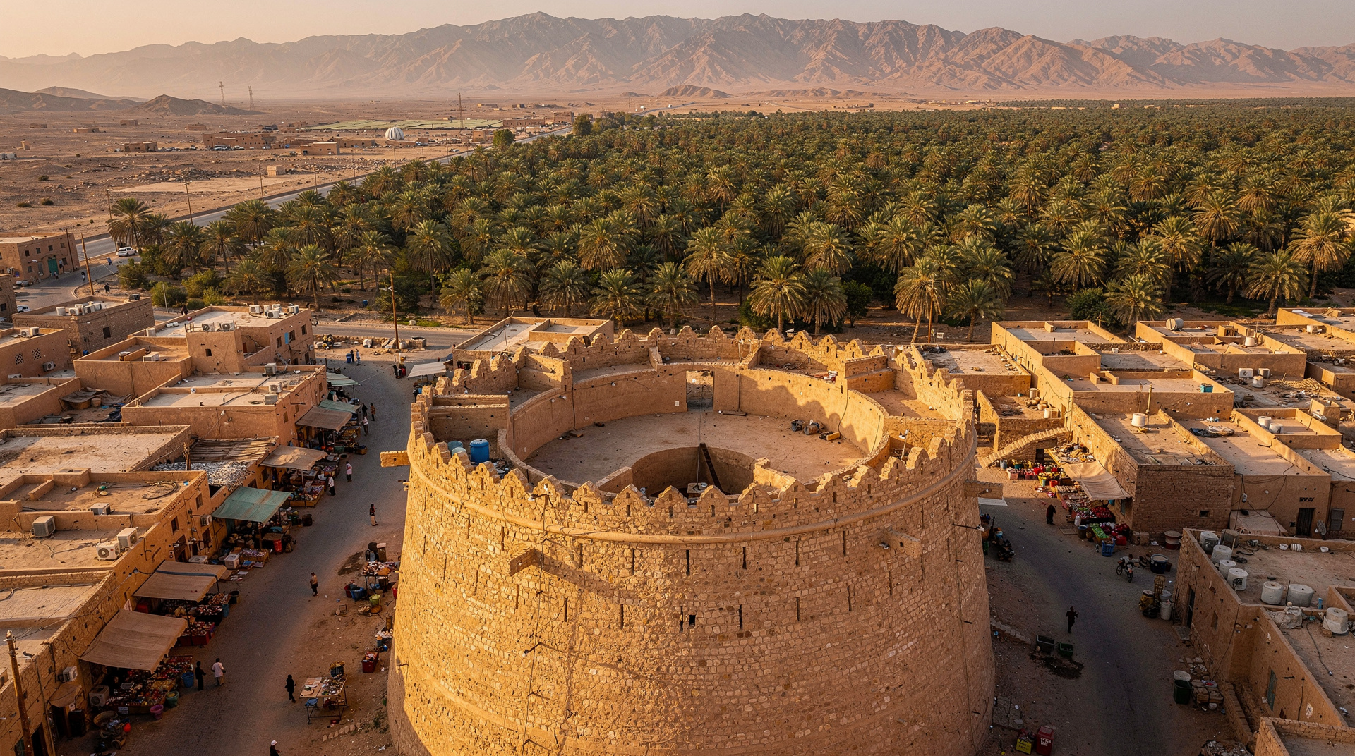
Wadi Bani Awf begins at the coastal town of Rustaq, which sits at the foot of the western Hajar range and has its own historical significance as a former Omani capital with a substantial fort. From Rustaq, the route climbs steeply into the mountains through a series of increasingly narrow wadis until it reaches the narrow slot canyon section known locally as Snake Canyon — a passage of such dramatic proportions that first-time visitors typically stop their vehicles and stand in silence for a moment before continuing.
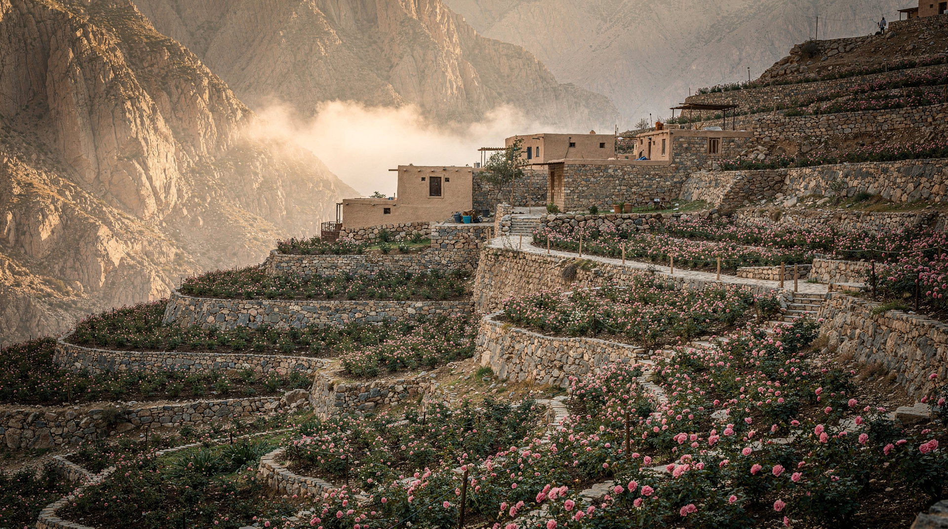
Beyond Snake Canyon, the route climbs to Bilad Sayt, a Beehive-shaped stone village perched on a small fertile plateau at approximately 1,000 metres elevation. The village has been inhabited for centuries, its terrace agriculture and falaj water channels still functional. From Bilad Sayt, the onward route descends through the eastern Hajar to connect with the inland road network toward Nizwa and the interior.
Total distance from Rustaq to the inland road exit is approximately 80 kilometres. In terms of time, allow six to eight hours for the full traverse including stops. This is not a route for rushing.
Snake Canyon (Wadi Bani Awf Narrows)
The most dramatic section of the route, Snake Canyon is a geological improbability — a slot cut through ancient limestone that at its narrowest squeezes a 4WD vehicle through gaps of centimetres to spare on each side. The walls rise 200 to 300 metres above the canyon floor, which is occupied by the dry wadi bed and the “road” — in truth, a vehicle track that follows the canyon floor between boulders, through shallow seasonal pools, and over polished rock surfaces.
The name derives from the serpentine quality of the canyon course, which bends back on itself repeatedly in tight switchbacks. The light in the canyon changes character every few minutes as the sun moves — from deep shade to narrow slashes of direct illumination that bounce off canyon walls in complex, beautiful ways.
This section is the most technically demanding of the route. The rock surfaces can be slippery, the gaps genuinely narrow, and the occasional boulder requires careful line selection. Experienced drivers find it manageable; nervous drivers find it stressful. The key is patience and a willingness to walk the more complex sections before committing the vehicle.
Bilad Sayt Village
Sitting on its isolated plateau surrounded by the highest peaks of the western Hajar, Bilad Sayt is one of the most visited villages in Oman by those who know about it, and unknown to the majority of visitors. The stone buildings, the terraced date and pomegranate gardens, and the ancient falaj channels that bring water from underground springs to the village combine to create a scene that seems to belong to another century — until a solar panel or satellite dish reveals the 21st.
The villagers are accustomed to travellers arriving by 4WD. Respect for privacy and permission before photographing people are important. The walk around the village perimeter, following the ancient paths between the terraces, takes about an hour and provides views across the surrounding mountains that justify the drive on their own.
There is a small shop in the village where water and basic supplies can be purchased. This is the only reliable resupply point between Rustaq and the interior road.
Technical Route Information
Vehicle Requirements
A 4WD vehicle with low-range gearing is absolutely mandatory. High-clearance SUVs with part-time 4WD and a low-range transfer case are adequate for experienced drivers. Soft-roaders, crossovers, and any vehicle without genuine low-range capability should not attempt this route.
Tyre condition matters significantly. Sidewall strength is important for the rocky sections. Deflating tyres to 25 to 28 psi for the canyon section improves traction on rock and increases sidewall flexibility to absorb impacts. Carry a portable compressor to reinflate for the tarmac sections.
Ground clearance should be a minimum of 20 centimetres. Skid plates on the front subframe and transfer case are beneficial but not essential.
Convoy Considerations
Driving this route alone is inadvisable. If a vehicle breaks down in Snake Canyon, recovery is extremely difficult. A minimum of two vehicles means that one can seek help while the other remains. Many experienced drivers insist on three vehicles as the minimum for a remote route of this character.
If driving independently, inform someone reliable of the planned route and expected exit time. Carry a satellite communicator capable of sending a position and emergency signal without relying on cellular networks, which are absent through most of the canyon section.
Fuel
There is no fuel available between Rustaq and the inland road network exit. Calculate the full route distance and ensure sufficient reserve. A full tank at departure from Rustaq is adequate for most vehicles with reasonable fuel economy. Carrying a spare jerry can of 10 to 20 litres adds insurance on a route where a wrong turn or multiple attempts at difficult sections can significantly increase consumption.
Water and Emergency Supplies
Carry a minimum of five litres of drinking water per person. The route has no reliable water sources — the wadi may carry water or pools in winter after rain, but this should not be relied upon. A basic recovery kit including a tow strap, recovery boards, a high-lift jack, and basic tools is appropriate for this class of route.
First aid kit, emergency blanket, and a charged battery pack for electronics are sensible additions.
Seasonal Considerations
Best Season: October through April
The optimal time for Wadi Bani Awf is the cool season. Air temperatures in the mountains are pleasant — often ten to fifteen degrees cooler than the coast — and the rock surfaces are dry and grippy. The light quality in this season, particularly in the canyon section, is exceptional.
After significant rainfall, typically December through February, the wadi may carry water. This is generally manageable but adds complexity — fast-moving water in a confined canyon is dangerous, and the route should be abandoned if water levels are rising or conditions are uncertain. Check local weather conditions before departure and be prepared to turn back.
Summer: Manageable with Early Start
The canyon section is shaded enough that summer driving is possible, but the exposed sections above Bilad Sayt and on the high plateau are exposed and hot. An extremely early start — before sunrise — is necessary to complete the route before the worst heat. Summer visits require heightened water preparation and a realistic assessment of heat risk.
Rainy Season Hazards
Flash floods in the wadis of the Hajar range are a genuine danger and have caused fatalities. Rain falling on the mountains above, even without visible cloud directly overhead, can generate floods with minimal warning. Do not camp or park in a wadi bed. If weather conditions are uncertain, postpone the route.
Combining Wadi Bani Awf with Rustaq Fort and Hot Springs
Making Wadi Bani Awf the centrepiece of a full day itinerary that begins at Rustaq adds historical context to the adventure.
Rustaq Fort is one of the most impressive in Oman — a multi-towered structure dating to the pre-Islamic era but substantially rebuilt in the 17th century. The fort houses a small museum and commands views over the agricultural plain that surrounds the town. Budget an hour for the fort.
Ain Al Kasfa, a hot spring near Rustaq, provides a restorative stop either before or after the canyon drive. The water temperature is approximately 45 degrees and the setting — a series of pools fed by a spring emerging from a limestone hillside — is pleasant. The spring is well-maintained and has basic changing facilities.
For those connecting the mountain drive with broader interior exploration, the route toward Nizwa passes through the historical town of Al Hamra, covered in the guide to Al Hamra and Misfat al Abriyeen, and connects to the Jebel Akhdar highland area — one of Oman’s most spectacular landscapes. Those looking for a guided adventure in the same mountain region should note the Jebel Shams full-day adventure tour through Snake Canyon, which covers adjacent canyon terrain with an experienced guide and without the requirement for your own capable 4WD.
The Route as Part of a Multi-Day Circuit
The most rewarding way to experience Wadi Bani Awf is as part of a multi-day circuit of the western Hajar range that connects coast, mountains, and desert interior.
A three-day circuit might begin in Muscat, drive to Rustaq for the fort and hot spring, complete the canyon route and stay in Bilad Sayt or a camp nearby, then continue to Nizwa for the fort and souq before looping through Jebel Akhdar and returning to Muscat via the interior highway. This covers the full range of mountain Oman in a compact and logical sequence.
For those adding a desert component, the route from Nizwa through the interior to Wahiba Sands adds another full day and converts the circuit into a comprehensive Oman interior experience. See the guide to Wahiba Sands for the eastern desert leg. The rock climbing guide also covers the Wadi Bani Awf canyon walls, which are among the best sport climbing venues in the country.
Photography Notes
Wadi Bani Awf is one of the most photographed routes in Oman, and the photographic opportunities justify every bit of that attention. Snake Canyon offers dramatic light-and-shadow interplay that rewards slow exploration with a camera. The wide-angle view from inside the narrowest sections, with canyon walls converging hundreds of metres above, is a composition that is difficult to do poorly.
Bilad Sayt is most atmospheric in the early morning before the harsh midday light flattens the terrace geometry. The surrounding peaks catch the first light while the village remains in shadow, which creates a documentary-quality contrast that works well for landscape photography.
A polarising filter is useful for the canyon sections to manage contrast between the bright sky visible above and the shaded walls. A wide-angle lens in the 14 to 24mm range makes the most of the canyon geometry.
Frequently asked questions about Wadi Bani Awf Off-Road: Oman’s Most Spectacular Mountain Drive
Can I drive Wadi Bani Awf in a rented 4WD from Muscat?
Yes, provided the rental vehicle has genuine low-range 4WD capability and the rental agreement permits off-road driving — check this specifically, as many rental contracts exclude “off-road” use. Standard Omani hire vehicles like the Toyota Prado and Nissan Patrol are appropriate. Compact SUVs marketed as 4WD but without a proper transfer case are not adequate.
How long does the full route take?
Allow six to eight hours for the complete traverse including all stops, a proper visit to Bilad Sayt village, and the canyon section. Starting by 07:00 from Rustaq allows completion before dark in winter months. Summer requires starting earlier.
Is there a guide service for Wadi Bani Awf?
Yes. Several Muscat-based adventure tour operators offer guided full-day Wadi Bani Awf experiences that include vehicle transport, driver, and lunch. This is the recommended option for those without off-road driving experience or their own capable vehicle. The guides’ knowledge of route-finding and vehicle recovery on this specific track is valuable.
Are there toilets or facilities along the route?
There are no public toilet facilities along the canyon section. Bilad Sayt village has basic facilities available by request. Plan accordingly. The small shop in Bilad Sayt is the only place to purchase water or food on the route.
What happens if my vehicle breaks down in Snake Canyon?
Recovery in the canyon is genuinely difficult and may require specialist equipment and experienced recovery operators from Muscat or Rustaq. This is why a convoy of at least two vehicles is strongly recommended. With a satellite communicator, help can be summoned. Without one, the situation becomes significantly more complicated. Prevention through vehicle preparation is far preferable to any recovery scenario.
The Geology of the Al Hajar Range
Understanding the basic geology of the western Hajar makes the Wadi Bani Awf route significantly more interesting. The mountains here are made of ophiolite — ancient oceanic crust thrust up onto the continental plate during a tectonic collision approximately 80 million years ago. This makes the Al Hajar range geologically unique: it is one of the world’s most exposed and best-preserved ophiolite sequences, studied by geologists from around the world.
The grey-brown rock of the canyon walls is peridotite and harzburgite — the deep mantle material that underlies ocean crust. The greenish serpentinite that appears at certain points along the route is the same material altered by water infiltration over millions of years. The limestone of the upper sections is younger, deposited in a marine environment before the tectonic upheaval.
The canyon itself was cut by water — specifically, by the seasonal wadi floods that have worked at the rock for millions of years. The scale of this erosion is visible in the polished walls of Snake Canyon, where the rock surface has the rounded, smooth quality of water-worn stone even at the highest visible levels, indicating that at some point in geological history the canyon was completely filled with a torrent of water.
Local Communities Along the Route
The villages perched above the main wadi route — including Bilad Sayt and several smaller settlements on the high plateau — are inhabited by tribal communities whose presence in these mountains predates any recorded history. Their cultivation of the high valley floors, using traditional falaj water systems, and their construction of fortified stone houses designed for defence and insulation simultaneously, represent an adaptation to the mountain environment that deserves recognition beyond the visual.
Interaction with villagers encountered on the route should be approached with courtesy and some restraint. These communities have managed visitor relationships with varying success as the route has become more popular. Asking before photographing people, accepting any hospitality offered, and leaving the villages exactly as found are the appropriate basics.
The traditional knowledge held in these communities — of water sources, of navigation in the mountains, of the medicinal plants that grow in the wadi floors — is not systematically documented anywhere. A conversation with an elder who has walked these routes for sixty years carries information that no guidebook contains.
Wildlife of the Route
The Al Hajar Mountains support a range of wildlife that the bare rock surface of the canyon suggests would be absent. Arabian tahr — a wild goat-like animal endemic to Oman — inhabit the higher cliff sections and are occasionally visible from the canyon route. Look for them on ledges in the early morning and late afternoon.
Hyrax — small, fat-bodied animals that look vaguely like large guinea pigs and are surprisingly closely related to elephants — colonise the rock piles in the canyon and are frequently seen sunning themselves on boulders. They are bold and curious and may approach a stationary vehicle.
The bird life of the canyon is most active in the morning. Hume’s wheatear, pale crag martin, and various sunbird species inhabit the cliff faces. Egyptian vultures and Bonelli’s eagles patrol the upper ridges. The Lappet-faced vulture, one of the largest birds in the region, is occasionally seen soaring on thermals above the canyon in mid-morning.
Reptiles are abundant in the warmer months — the canyon walls host multiple gecko species and the wadi floor holds the Omani sand boa in less-visited sections. The Arabian horned viper is present but rarely encountered on the main track.